Leica RTC360 3D Reality Capture Solution – Plant
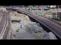
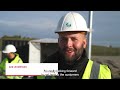
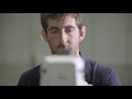
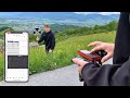
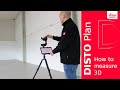
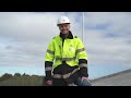
The Leica RTC360 3D reality capture solution empowers users to document and capture their environments in 3D, improving efficiency and productivity in the field and in the office through fast, simple-to-use, accurate and portable hardware and software. RTC360 3D laser scanner is the solution for professionals to manage project complexities with accurate and reliable 3D representations and discover the possibilities of any site.
Highly portable, highly automated, intuitive and designed for maximum productivity, the RTC360 solution efficiently combines a high-performance scanner, a smartphone app for edge computing for automatically registering scans in real time, and a high-performance office software to integrate the 3D model seamlessly into any workflow. Capture scans, including enriching High-Dynamic Range (HDR) imagery, in less than two minutes. Automatically record your moves from station to station to pre-register your scans in the field without manual intervention. Augment your data capture with information tags illustrating the opportunities for better planning, reflect site reality, and boost your teams’ situational awareness.
For more information, please visit: https://leica-geosystems.com/rtc360
Видео Leica RTC360 3D Reality Capture Solution – Plant канала Leica Geosystems AG
Комментарии отсутствуют
Информация о видео
16 октября 2019 г. 15:58:52
00:02:23
Другие видео канала