- Популярные видео
- Авто
- Видео-блоги
- ДТП, аварии
- Для маленьких
- Еда, напитки
- Животные
- Закон и право
- Знаменитости
- Игры
- Искусство
- Комедии
- Красота, мода
- Кулинария, рецепты
- Люди
- Мото
- Музыка
- Мультфильмы
- Наука, технологии
- Новости
- Образование
- Политика
- Праздники
- Приколы
- Природа
- Происшествия
- Путешествия
- Развлечения
- Ржач
- Семья
- Сериалы
- Спорт
- Стиль жизни
- ТВ передачи
- Танцы
- Технологии
- Товары
- Ужасы
- Фильмы
- Шоу-бизнес
- Юмор
How download landcover from google earth engine?
Master the process of exporting Land Use Land Cover (LULC) data directly from Google Earth Engine (GEE).
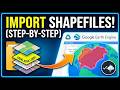
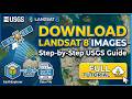
In this tutorial, we dive into the cloud-based power of Google Earth Engine to access and download high-resolution landcover datasets like ESRI 10m, ESA WorldCover, or MODIS. This method eliminates the need for downloading massive raw image tiles, allowing you to clip and export exactly what you need for your study area.
What You Will Learn:
How to search for Landcover datasets in the GEE Catalog.
Setting the Region of Interest (ROI) using imports or hand-drawn polygons.
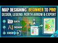
Understanding the legend and class values of LULC products.
Writing the script to Export to Drive in GeoTIFF format.
Selecting the appropriate scale (spatial resolution) for your project.
Key Code Snippets Covered:
ee.ImageCollection() - Browsing the data.
.filterBounds() - Clipping to your specific study area.
Export.image.toDrive() - The final step to get data into your GIS software.
Tools Mentioned:
Google Earth Engine (JavaScript API)
ArcGIS / QGIS (for post-download analysis)
Google Drive (for file storage)
Code used: https://code.earthengine.google.com/5d2c29ae3536e98a2bb0071a85a1e0fe
Suggested Hashtags:
#GoogleEarthEngine #LULC #RemoteSensing #GIS #SatelliteImagery #GeospatialAnalysis #LandCover #GEE
Видео How download landcover from google earth engine? канала GIS_withWr_khan
In this tutorial, we dive into the cloud-based power of Google Earth Engine to access and download high-resolution landcover datasets like ESRI 10m, ESA WorldCover, or MODIS. This method eliminates the need for downloading massive raw image tiles, allowing you to clip and export exactly what you need for your study area.
What You Will Learn:
How to search for Landcover datasets in the GEE Catalog.
Setting the Region of Interest (ROI) using imports or hand-drawn polygons.
Understanding the legend and class values of LULC products.
Writing the script to Export to Drive in GeoTIFF format.
Selecting the appropriate scale (spatial resolution) for your project.
Key Code Snippets Covered:
ee.ImageCollection() - Browsing the data.
.filterBounds() - Clipping to your specific study area.
Export.image.toDrive() - The final step to get data into your GIS software.
Tools Mentioned:
Google Earth Engine (JavaScript API)
ArcGIS / QGIS (for post-download analysis)
Google Drive (for file storage)
Code used: https://code.earthengine.google.com/5d2c29ae3536e98a2bb0071a85a1e0fe
Suggested Hashtags:
#GoogleEarthEngine #LULC #RemoteSensing #GIS #SatelliteImagery #GeospatialAnalysis #LandCover #GEE
Видео How download landcover from google earth engine? канала GIS_withWr_khan
Комментарии отсутствуют
Информация о видео
17 апреля 2026 г. 14:54:18
00:04:14
Другие видео канала


![How to Download High-Resolution (4K) Images from Google Earth Pro [2026]](https://i.ytimg.com/vi/2DqYnObh24Q/default.jpg)

