Flying over Ronda Tajo and Puente Nuevo - Mavic Pro
Flying over Ronda's Puente Nuevo (New Bridge) and Tajo (Gorge)
Puente Nuevo is the newest of the three bridges in Ronda crossing the Guadalevin River. The Tajo is 120m long, the bridge is 100m high and 66m in length. Work on it started in 1759 and took 34 years to complete. Ronda is not on a restricted flight area for drone flying according to IcarusRPA application authorised by AESA (Spanish Aviation Service)
Видео Flying over Ronda Tajo and Puente Nuevo - Mavic Pro канала 2bsure
Показать
Комментарии отсутствуют
Информация о видео
Другие видео канала
 Cascada De Cimbarra, Cimbarrillo y Charco Negrillo - Aldeaquemada, Jaén
 La Peña De Los Enamorados Antequera
 Río Del Padrón, Sierra Bermeja Estepona
 Torca (Depression) De Mollina
 Flying above the clouds - DJI Mavic Air 2
 Fog and cloud Inversion
 Flying over Pico De Las Grajas,Tajo Algarin and Zahara de la Sierra Castillo
 Acebuchal - Venta Panaderos
 Near home in Malaga region early 2021 Mavic Pro - Cerca mi hogar en Malaga 2021 Mavic Pro
 Misty Sierra Blanca from Puerto Rico Bajo and La Montua
 Angosturas del Río Guadalmina, Benahavís
 Cloud hyperlapse DJI Mavic Air 2/Air 2s
 'Badlands' Of Purullena and Gorafe, Granada - DJI Mavic Pro
 Tajo Negro 1.134m Sierra Blanca
 View from Cerro El Fuerte, Frigiliana
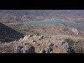 Flying over Tajo Algarin 1, 041m El Gastor, Cádiz /DJI Mavic Pro
 Río Campanillas y la cola de Embalse de Casasola, Almogía
 Foggy mountains
 Presa del Golpeadero Antequera, Malaga
 Feonh winds over El Torcal de Antequera