- Популярные видео
- Авто
- Видео-блоги
- ДТП, аварии
- Для маленьких
- Еда, напитки
- Животные
- Закон и право
- Знаменитости
- Игры
- Искусство
- Комедии
- Красота, мода
- Кулинария, рецепты
- Люди
- Мото
- Музыка
- Мультфильмы
- Наука, технологии
- Новости
- Образование
- Политика
- Праздники
- Приколы
- Природа
- Происшествия
- Путешествия
- Развлечения
- Ржач
- Семья
- Сериалы
- Спорт
- Стиль жизни
- ТВ передачи
- Танцы
- Технологии
- Товары
- Ужасы
- Фильмы
- Шоу-бизнес
- Юмор
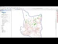
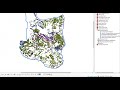
Line Density Tool ArcGIS Pro
Line Density Tool, Density Toolset, Spatial Analyst Toolbox
Summary
Calculates a magnitude-per-unit area from polyline features that fall within a radius around each cell.
Usage
Only the portion of a line within the neighborhood is considered when calculating the density. If no lines fall within the neighborhood at a particular cell, that cell is assigned NoData.
Larger values of the radius parameter produce a more generalized density raster. Smaller values produce a raster that shows more detail.
The values on the output raster will always be floating point.
The Output cell size parameter can be defined by a numeric value or obtained from an existing raster dataset. If the cell size hasn’t been explicitly specified as the parameter value, it is derived from the Cell Size environment if it has been specified. If the parameter cell size or the environment cell size have not been specified, but the Snap Raster environment has been set, the cell size of the snap raster is used. If nothing is specified, the cell size is calculated from the shorter of the width or height of the extent divided by 250 in which the extent is in the output coordinate system specified in the environment.
If the cell size is specified using a numeric value, the tool will use it directly for the output raster.
If the cell size is specified using a raster dataset, the parameter will show the path of the raster dataset instead of the cell size value. The cell size of that raster dataset will be used directly in the analysis, provided the spatial reference of the dataset is the same as the output spatial reference. If the spatial reference of the dataset is different than the output spatial reference, it will be projected based on the selected Cell Size Projection Method value.
For data formats that support Null values, such as file geodatabase feature classes, a Null value will be ignored when used as input.
If the area unit scale factor units are small relative to the features (length of line sections), the output values may be small. To obtain larger values, use the area unit scale factor for larger units (for example, square kilometers versus square meters).
density, kernel density, line density in arcgis, density mapping, drainage density, stream density, line density, line density in arcmap, line density map, kernel density in arcgis, lineament density, arcgis pro: point & line density, arcgis pro: kernel density, lineament density map, point density in arcgis, drainage density in arcgis pro, incident density, density mapping by arcgis, drainage density map in arcgis pro, using the proximity tools
أكثر من 50 أمتحان عن برنامج الـ ArcGIS Pro من خلال الرابط التالي:
https://bit.ly/ArcGISProQuizzes
الـ GIS وبرنامج ArcGIS Pro:
https://www.youtube.com/watch?v=WaZVPr9_LVU&t=606s
التعامل والتفاعل مع البيانات الجغرافية ArcGIS Pro:
https://www.youtube.com/watch?v=zJ8jUBbX0Bs&t=2051s
إنشاء البيانات الجغرافية وإدارتها ArcGIS Pro:
https://www.youtube.com/watch?v=sFd6xsIhIjQ
تحليل البيانات:
https://www.youtube.com/watch?v=Eou5MVnNI-Y&t=1765s
العمل والتحليل مع البيانات ثلاثية الأبعاد:
https://www.youtube.com/watch?v=6U20Ey9qDx8
لمتابعة موقع GISforWE من هنا:
https://bit.ly/GISforWE
تنزيل برامج ArcGIS Pro مدى الحياة وقاعدة بيانات جاهزة للتعلم:
https://gisforwe.blogspot.com/2022/11/%20ArcGIS.html
موقع لكل مهتم في مجال نظم المعلومات الجغرافية GIS من هنا:
https://gisforwe.blogspot.com/
اليك صفحه ومجموعة على الفيس بوك لتعلم أكثر بما يخص نظم المعلومات الجغرافية (GIS) و برامج ArcGIS Pro من خلال هذه الروابط:
مجموعة على الفيس بوك ArcGIS Pro :
https://www.facebook.com/groups/486795389231905
مجموعة على الفيس بوك GIS for WE - ArcGIS:
https://www.facebook.com/groups/ESRI.ArcGIS
صفحة الفيس بوك GIS for WE:
https://www.facebook.com/profile.php?id=100053947103452
#ArcGISPro
#Analysis_GIS
#Data_Analysis
اعداد وتقديم المطور والباحث في مجال نظم المعلومات الجغرافية حسام جعبه
رام الله - فلسطين.
#GISforWE
GIS for World of E-Learning
Видео Line Density Tool ArcGIS Pro канала Husam Jubeh
Комментарии отсутствуют
Информация о видео
22 декабря 2024 г. 21:00:05
00:01:10
Другие видео канала