- Популярные видео
- Авто
- Видео-блоги
- ДТП, аварии
- Для маленьких
- Еда, напитки
- Животные
- Закон и право
- Знаменитости
- Игры
- Искусство
- Комедии
- Красота, мода
- Кулинария, рецепты
- Люди
- Мото
- Музыка
- Мультфильмы
- Наука, технологии
- Новости
- Образование
- Политика
- Праздники
- Приколы
- Природа
- Происшествия
- Путешествия
- Развлечения
- Ржач
- Семья
- Сериалы
- Спорт
- Стиль жизни
- ТВ передачи
- Танцы
- Технологии
- Товары
- Ужасы
- Фильмы
- Шоу-бизнес
- Юмор
Visualize Satellite NDVI Data in Python with Rasterio &Matplotlib | Anaconda Setup
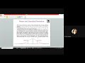
🛰 GIS Lab Practical 2 is here! In this video, we open a real satellite image
(.tif file), read its pixel values, and render it as a professional NDVI Map using
Python — inside Jupyter Notebook!
This is perfect for students, researchers, and anyone starting out in geospatial
Python programming.
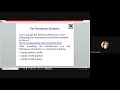
📌 What You'll Learn:
✅ Set up a fresh Anaconda virtual environment (Python 3.10) from scratch
✅ Install rasterio and matplotlib the right way (conda-forge recommended)
✅ Open a satellite .tif file using rasterio.open()
✅ Read raster band data as a NumPy array with src.read(1)
✅ Visualize satellite data with plt.imshow()
✅ Understand the visualization pipeline: array → colors → map
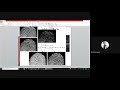
✅ Create a publication-quality NDVI Map using the RdYlGn colormap
🟢 Green = Healthy Vegetation | 🔴 Red = Bare Land / Water / Non-vegetated areas
📂 Libraries Used: rasterio, matplotlib
🐍 Environment: Anaconda (Jupyter Notebook), Python 3.10
⏱ Timestamps:
00:00 – Introduction
01:00 – Anaconda Setup & conda environment creation
03:00 – Installing rasterio & matplotlib
04:30 – Loading the NDVI .tif File
06:30 – Code Explanation Line by Line
08:30 – Professional NDVI Map with RdYlGn colormap
10:30 – Recap & Outro
📥 Drop a screenshot of YOUR NDVI Map in the comments! I'd love to see it.
🔔 Subscribe for the next GIS Practical — NDVI thresholds and region cropping!
#Python #GIS #NDVI #Rasterio #Matplotlib #SatelliteImagery #JupyterNotebook
#AIwithDrRashi #GISPractical #RemoteSensing
Видео Visualize Satellite NDVI Data in Python with Rasterio &Matplotlib | Anaconda Setup канала Learn Computer Science with Prof. Rashi
(.tif file), read its pixel values, and render it as a professional NDVI Map using
Python — inside Jupyter Notebook!
This is perfect for students, researchers, and anyone starting out in geospatial
Python programming.
📌 What You'll Learn:
✅ Set up a fresh Anaconda virtual environment (Python 3.10) from scratch
✅ Install rasterio and matplotlib the right way (conda-forge recommended)
✅ Open a satellite .tif file using rasterio.open()
✅ Read raster band data as a NumPy array with src.read(1)
✅ Visualize satellite data with plt.imshow()
✅ Understand the visualization pipeline: array → colors → map
✅ Create a publication-quality NDVI Map using the RdYlGn colormap
🟢 Green = Healthy Vegetation | 🔴 Red = Bare Land / Water / Non-vegetated areas
📂 Libraries Used: rasterio, matplotlib
🐍 Environment: Anaconda (Jupyter Notebook), Python 3.10
⏱ Timestamps:
00:00 – Introduction
01:00 – Anaconda Setup & conda environment creation
03:00 – Installing rasterio & matplotlib
04:30 – Loading the NDVI .tif File
06:30 – Code Explanation Line by Line
08:30 – Professional NDVI Map with RdYlGn colormap
10:30 – Recap & Outro
📥 Drop a screenshot of YOUR NDVI Map in the comments! I'd love to see it.
🔔 Subscribe for the next GIS Practical — NDVI thresholds and region cropping!
#Python #GIS #NDVI #Rasterio #Matplotlib #SatelliteImagery #JupyterNotebook
#AIwithDrRashi #GISPractical #RemoteSensing
Видео Visualize Satellite NDVI Data in Python with Rasterio &Matplotlib | Anaconda Setup канала Learn Computer Science with Prof. Rashi
rasterio matplotlib NDVI visualization Python satellite image Python open tif file Python rasterio tutorial plt imshow satellite RdYlGn colormap Anaconda GIS setup conda environment Python Jupyter notebook GIS NDVI map Python GIS lab practical remote sensing Python satellite data visualization numpy raster geospatial Python beginner vegetation index Python NDVI colormap satellite NDVI map Python remote sensing GIS tutorial beginners India
Комментарии отсутствуют
Информация о видео
Другие видео канала