Image of the Week - Landsat 9 First Images!
Landsat 9 launched into space on September 27th, 2021. The "first light" images arrived on October 31st. On that day the satellite captured: algal blooms in Lake Erie, the glaciers of the Himalayas, bush fires in Australia's Eucalypt Woodlands, coastal communities on the Florida panhandle, and deserts, mountains and mesas across the Navajo Nation. Imagery from Landsat 9 will maintain and extend the Landsat program's nearly 50 year record of Earth surface change. The new data stream will be available to the public in early 2022.
USGS Video: https://www.usgs.gov/media/videos/image-week-landsat-9-first-images
Видео Image of the Week - Landsat 9 First Images! канала USGS
USGS Video: https://www.usgs.gov/media/videos/image-week-landsat-9-first-images
Видео Image of the Week - Landsat 9 First Images! канала USGS
Показать
Комментарии отсутствуют
Информация о видео
Другие видео канала
 Landsat 8: 5-Year Anniversary
 Forecast Mekong: Virtual River of Life
 Landsat Collections - RMSE
 February 14, 2023 — Continued lava lake activity at Kīlauea summit
 Living with Fire: Fire Decision Model
 I Am A...Wildlife Biologist
 Lake Powell Water Quality Samples at a Specific Depth
 Landsat in Action - Changing Forest Phenology with Andrew Elmore
 USGS Emergency Management 101 Onsite leadership and communication
 Vent that formed on the wall of Halema‘uma‘u crater, Kīlauea volcano — June 7, 2023
 Climate Science Champions, Season 1: Vanessa von Biela, Research Fish Biologist
 June 18, 2023 — Video of southwest wall vent in Halemaʻumaʻu
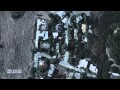 Living with Fire: Human Fire Ignitions
 NMIC - 2017 Mineral Commodity Summaries Release
 Swimming Pools at Yellowstone? (Yellowstone Monthly Update - June 2024)
 Lava fountaining in Halema'uma'u crater—October 12, 2021
 Collecting water data for the U.S.
 Churn Operation
 2011: The Year of the Flood
 Hatching an Engineer
 Advances in Streamgaging | Reach-Scale Monitoring Experiment (2 of 2)