- Популярные видео
- Авто
- Видео-блоги
- ДТП, аварии
- Для маленьких
- Еда, напитки
- Животные
- Закон и право
- Знаменитости
- Игры
- Искусство
- Комедии
- Красота, мода
- Кулинария, рецепты
- Люди
- Мото
- Музыка
- Мультфильмы
- Наука, технологии
- Новости
- Образование
- Политика
- Праздники
- Приколы
- Природа
- Происшествия
- Путешествия
- Развлечения
- Ржач
- Семья
- Сериалы
- Спорт
- Стиль жизни
- ТВ передачи
- Танцы
- Технологии
- Товары
- Ужасы
- Фильмы
- Шоу-бизнес
- Юмор
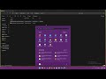
How to Download DEM, SLOPE, HILLSHADE for Free | Banglai-GIS
Welcome to Banglai GIS, your go-to channel for learning Geographic Information Systems (GIS) and topography in Bangla! 🌍
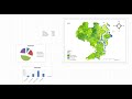
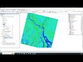
In this video, we provide a step-by-step guide to download GIS data for SLOPE, DEM (Digital Elevation Model), HILLSHADE, ASPECT, and ROUGHNESS from OpenTopography, totally free of charge. Whether you're a student, researcher, or GIS enthusiast, this data will help you analyze and visualize terrain and topographic features.
🔹 How to Download GIS Data:
Visit the OpenTopography Download Page:
OpenTopography Link
Select the datasets you need (SLOPE, DEM, HILLSHADE, ASPECT, ROUGHNESS) and follow the simple instructions.
🔹 Features of the GIS Data:
SLOPE: Measure the steepness of the terrain.
DEM: Digital Elevation Models for geographic regions.
HILLSHADE: Create 3D visualizations with light and shadow.
ASPECT: Determine the direction of slopes.
ROUGHNESS: Analyze surface irregularities for terrain modeling.
💬 Need More Information or Help?
If you have any questions or face issues, feel free to reach out to us:
WhatsApp for more Informations: +8801774690633
Hashtags:
#BanglaiGIS #GISinBangla #OpenTopography #FreeDownload #Slope #DEM #Hillshade #GISResources #GeographicInformationSystems
Видео How to Download DEM, SLOPE, HILLSHADE for Free | Banglai-GIS канала Banglai- GIS
Комментарии отсутствуют
Информация о видео
28 февраля 2026 г. 2:21:44
00:08:33
Другие видео канала