Giant Intake Vortex - Denison Dam, Lake Texoma - 150605
Click here to learn more: https://www.youtube.com/watch?v=JlqJsz7r1P0
Here's a very unique view of an intake vortex, created as water enters the Denison Dam spillway on Lake Texoma.
The vortex is approximately 8 feet in diameter and capable of sucking in a full-sized boat, so please heed all safety buoys and caution signs.
This is a normal occurrence when flood waters are released from the reservoir via flood control gates.
Learn more at http://www.facebook.com/usacetulsa
Video by Edward N. Johnson
U.S. Army Corps of Engineers, Tulsa District
ABOUT DENISON DAM & LAKE TEXOMA
Authorization: Flood Control Act approved June 28, 1938, Project Document HD 541, 75th Congress, 3d Session (flood control and power); Public Law 868, 76th Congress, 3d Session, approved October 17, 1940, (improving navigation, regulating flow of Red River, controlling floods, and other beneficial uses); Public Law 454, 78th Congress, 2d Session, approved September 30, 1944, (impoundment designated as Lake Texoma); Public Law 273, 83rd Congress, 1st Session, approved August 14, 1953, (Denison water supply storage); Public Law 164, 84th Congress, 1st Session, approved July 15, 1955, (construction of Willis Site Bridge); Public Law 146, 85th Congress, 1st Session, approved August 14, 1957, Project Document HD 541, 75th Congress, 3d Session, (Sherman water supply); Public Law 282, 91st Congress, 1st Session, approved July 19, 1970, (water supply dam on Big Mineral Arm); Public Law 662, 99th Congress, 2d Session, approved November 17, 1986, (added recreation as a project purpose and authorized reallocation of additional storage for water supply).
Location: On the Red River at river mile 725.9, 5 miles northwest of Denison in Grayson County, Texas.
Status: Completed
Purpose: Flood control, water supply, hydroelectric power, regulation of Red River flows, improvement of navigation, and recreation.
History of Construction: Construction began in August 1939 and was completed in February 1944. The project was first available to operate for full flood control without any restrictions in January 1944. The first hydroelectric turbine was placed on line in March 1945 and the second in September 1949. Construction of a highway bridge across Lake Texoma at the Willis Ferry site started April 24, 1958, and was completed October 30, 1960. The 5,426-foot-long bridge replaces a former crossing south of Woodville, Oklahoma, on Oklahoma State Highway 99 and Texas State Highway 91. The roadway surface is about 37 feet above the top of the power pool.
Type of Structure: The structure is a rolled earth-filled embankment with a rock-protected upstream slope. The main embankment is 15,200 feet long. The maximum height of the structures is 165 feet above the streambed. A rolled earthfill dike 5,870 feet long and 15 feet high is located in the vicinity of Platter, Oklahoma. The Cumberland levee is 23,480 feet long with a crest elevation of 647.0. Highway 75A crosses the top of the dam.
Spillway & Outlet Works: The uncontrolled spillway is a concrete, gravity, chute-type structure, 2,000 feet long, located in a saddle on the right bank. Spillway capacity at maximum pool (elevation 666.4) is 1,050,000 cubic feet per second. The outlet works consist of three 20-foot-diameter, concrete conduits through the embankment equipped with six 9- by 19-foot vertical lift gates and one emergency gate. Capacity of the outlet works is 67,500 cfs at the top of the flood control pool and 60,120 cfs at the top of the power pool. Limiting channel capacity below Denison Dam is about 60,000 cfs.
Hydrologic Data: The estimated peak discharge for the May through June 1908 flood was 470,000 cfs. The volume was 8,517,000 acre-feet which is equivalent to 4.73 inches of runoff. The peak inflow for the May 1990 flood was 300,000 cfs with a volume of 5,087,000 acre-feet. The peak inflow for the May through June 1987 flood was 315,000 cfs with a volume of 2,879,000 acre-feet. The total volume of inflow for the 1957 flood was 8,364,000 acre-feet.
Видео Giant Intake Vortex - Denison Dam, Lake Texoma - 150605 канала usacetulsa
Показать
Комментарии отсутствуют
Информация о видео
Другие видео канала
 ladybower dam overflows
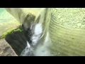 GoPro vs. 30" underwater vortex
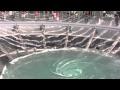 'Take 5 Tour' - Whirlpool at Marine Sands Singapore
 Lake Berryessa Glory Hole Sucks in a Poor Duck
 आखिर हनुमान ज़ी और बरमूडा ट्राइंगल में राज़ खुल ही गया अमर होने का !! Barmuda triangle
 Dykon Pipeline Blasting - Atlas Pipeline - OK -1
 Naruto Whirlpools 鳴門渦潮
 Demopolis Lock Whirlpools!
 Tornado Whirlpool Maker Science Kit ~ Incredible Science
 Tenu dam,when all dam doors are open
 Taming the Raging Red - Denison Dam Documentary
 Amazing Powerful Whirlpool!
 Amazing monstrous whirlpool / Чудовищный водоворот / Dvietes atvars / Torbellino / Tourbillon
 Azerbaijan mud volcanoes
 Delta P
 Vartry Reservoir, Upper Valve Tower and Spillway - 4K
 Top 10 Ocean Phenomena
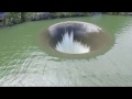 Monticello Dam Glory Hole 2 18 17 Pt 3
 Unclogging drain - huge whirlpool in the spirit of Post 10
 Minute by Minute: The Eruption of Mount St. Helens