2013 El Reno Tornado Synced (48 Synced Videos)
This video has the purpose of displaying several views of the tornado at the same time for a more clear, scientific analysis. This video uses various storm chaser and storm chaser groups video and I do not claim their video in any means.
All the links of the videos used are displayed between 0:15 and 1:00. Please watch the original videos to give support to these storm chasers, enthusiasts and scientists. They deserve the attention and praise for their video directly, not here.
Also make sure to check out the Tornado Environment Display (TED), which provided many videos you see here: http://el-reno-survey.net/ted/
Tornado Timeline:
6:00pm CDT : Wall Cloud appears from storm base.
6:00pm - 6:03pm : Several small spin-ups occur beneath the wall cloud/mesocyclone.
6:03pm : Tornado touches down
6:03pm - 6:06pm : The tornado maintains a multi-vortex structure travelling SSE at around 20mph
6:06pm - 6:07pm : The tornado takes the form of a "bowl-shaped" tornado.
6:07pm - 6:09pm : The tornado regains a multi-vortex form.
6:09pm - 6:11pm : The tornado becomes a stout cone/wedge.
6:11pm : The tornado becomes partially rain-wrapped.
6:13pm : The tornado becomes a pronounced wedge and is becoming much more shrouded in rain.
6:14pm - 6:16pm : The main wedge circulation is surrounded by several large satellite tornadoes inferring the transition to a MVMC (Multi-vortex mesocyclone) with tornadic winds.
6:15pm - 6:16pm : The tornado becomes very heavily shrouded in rain and appears to melt away (most likely due to transition into MVMC).
6:17pm - 6:18pm : Rain clears away noticeably to reveal the tornado has returned to a multi-vortex like structure while the tornadic windfield grows to mammoth proportions.
6:18pm - 6:19pm : Rain briefly shrouds the tornado again.
6:19pm : Rain clears somewhat to reveal stout cone/multi-vortex stovepipe as it crosses US-81.
6:20pm : The tornado become completely wrapped in rain, though the tornadic windfield is the visible rain curtains.
6:21pm - 6:22pm : Rain clears out North of the tornado providing a few viewers a view of the tall cone/stovepipe tornado. Meanwhile viewers South of the tornado can see a ground scraping mesocyclone (the MVMC) very slightly behind the heavy rain.
6:22pm - 6:23pm : The tall cone/stovepipe tornado appears to very quickly grow into an extremely large wedge (with small sub-vortices inside it) is viewed from the North while Southern viewers can now see the large ground scraping MVMC but are unable to view the wedge itself as rain inside the MVMC obscures their view.
6:23pm - 6:26pm : The wedge starts to break down into smaller vortexes (even though these are the same size as regular tornadoes or even larger) and begin to orbit around each other under the MVMC. The rain inside the MVMC clears out giving viewers from the South a view of the tornado.
6:26pm - 6:30pm : The main tornado melts away into more rain that is collecting in the MVMC and good views of the tornado vanish from all angles. Only the MVMC is visible now.
6:30pm - Onwards : The rain-wrapped MVMC slowly weakens and shrinks until it dies on I-40 at 6:40pm.
This timeline is my personal interpretation of the life of this tornado and shouldn't be taken as fact. This is just how I believe the tornado progressed based on what can be observed by watching the video.
Видео 2013 El Reno Tornado Synced (48 Synced Videos) канала SirTumbl3
Показать
Комментарии отсутствуют
Информация о видео
Другие видео канала
 El Reno Tornado 2013 - World's largest tornado - Storm Spotting Operations -
 Tornado Chasers, S2 Episode 12: "Nemesis, Part 2" 4K
 El Reno: Lessons From the Most Dangerous Tornado in Storm Observing History
 Safety Lessons From El Reno
 Full Documentary: Oklahoma: Tornado Target
![El Reno, OK Tornado - KWTV9 Gary England [31 May 2013]](https://i.ytimg.com/vi/tGyZ66W4qh0/default.jpg) El Reno, OK Tornado - KWTV9 Gary England [31 May 2013]
El Reno, OK Tornado - KWTV9 Gary England [31 May 2013] Tornado Alley - Real Time Tornado: Moore, Oklahoma
 2013 A Storm Odyssey - Episode 1 - 05/31/13 The day the rules have changed
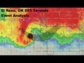 El Reno Tornado Analysis - Understanding a Chase Tragedy
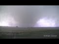 El Reno tornado of May 31, 2013
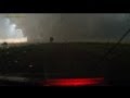 Escaping the largest EF5 tornado in history - El Reno, OK - full dashcam sequence
 Storm Chase & Spotting - Cope / Seibert Colorado Tornado - 28th May 2018
 The Last Chase: Remembering Tim Samaras | National Geographic
 People Are Hit by Tornadoes 2019
 Tornado Alley: Hattiesburg, Mississippi Full Episode
 2013 Moore Monster Tornado by Michael Lynn RAW ALL TCBI
 Tornado Alley - Real Time Tornado: Tuscaloosa, Alabama
 May 31st 2013 El Reno OK Tornado - New And Improved Footage!!
 Multivortex-Tornado south of El Reno, May 31, 2013
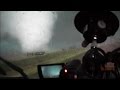 El Reno Oklahoma Tornado Full Storm Chase