Hurricane Dorian landfall in Marsh Harbour
READ BELOW.
THIS VIDEO IS ABSOLUTELY NOT FOR REBROADCAST OR COMMERCIAL USE. THIS YOUTUBE VIDEO IS NOT MONETIZED.
DISCLAIMER: NEVER ATTEMPT TO EMULATE THIS FOOTAGE. Storms are unpredictable, demonstrated by Hurricane Dorian's rapid intensification and subsequent stall over Grand Bahama. Even Category 1 winds can make free movement impossible. Airborne debris, such as that in this video, can easily maim or kill.
Please consider donating $5 to a charity of your choice to help Abaco rebuild or to help others affected by natural disasters, especially during the COVID-19 pandemic.
I will not respond to licensing requests. For scientific or chase-specific questions, DM me:
YT: This channel
IG: @jimmy_yunge
Additional notes:
- The eyewall portion of the video was taken from inside a concrete stairwell facing away from the wind within a reasonably sturdy structure; this combination of factors was unbelievably lucky and allowed me to continue recording through the most dangerous part of the storm. Not visible in this video is a vertical beam at the entrance of the staircase that offered some protection from possible incoming debris.
- The wide-angle lens and 16:9 cropping make the POV appear much closer to the winds than reality. Compare the 1133-1134 clip to the 1137 clip; these were shot standing in the same location, but the 1133-1134 clip used HD (not 4K), normal-FOV (not wide-angle) settings. The was some experimentation with the camera settings during the early-mid portion of the video; the 1100 clip, for example, was also shot in standard HD.
- KAMX Doppler radar imagery provided by Brian McNoldy, Sr. Research Associate, Rosenstiel School of Marine and Atmospheric Science, University of Miami (bmcnoldy.rsmas.miami.edu; twitter.com/bmcnoldy). The radar does not capture the near-surface eyewall and is therefore misleading. This is due to radar tilt, eyewall sloping, and earth curvature to a small extent. Bahamas radar imagery available at his miami.edu website above.
- The times in the lower left are accurate to within one minute. The times shown are local: Atlantic Standard Time, equivalent to Eastern Daylight Time. Between 1207 and 1226, recording was paused to take some photographs and consider relocating (although there were extremely few, if any, safe escape options). As a result, this video may not have captured the "exact" Vmax and RMW. However, the clip from 1226-1227 is a sufficiently good indication of the eyewall conditions. Maximum sustained winds in this video are likely 160+ mph, with gusts of 200+ mph.
Filmed with GoPro HERO7 at Abaco Beach Resort, Marsh Harbour.
Видео Hurricane Dorian landfall in Marsh Harbour канала Jimmy Yunge
Показать
Комментарии отсутствуют
Информация о видео
Другие видео канала
 2019-09-01 Hurricane Dorian coverage - The Weather Channel
 Treasure Cay, Abaco, Bahamas - December 2020
 Hurricane Laura Archive Footage from Southwest Louisiana
 Hurricane Dorian, Marsh Harbour, 2019
 Mighty Tropical Cyclone Debbie Shows Us Her Fury (Sailing SV Sarean) Ep. 3
 Mega Crashing Waves & Blinding Eye Wall Wind & Rain - 4K Stock Footage Typhoon Megi
 Down Town, Marsh Harbour, Abaco, Bahamas.
 Category 5 Hurricane Michael Far Western Mexico Beach, FL Eye Wall - 10/10/2018
 The RAW POWER of Hurricane Michael in Panama City: Sound & visuals in 4K
 Super Typhoon Haiyan: Inside the Belly of the Beast
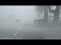 Hurricane Delta Massive Storm Surge And Eye, Creole, LA 10/9/2020
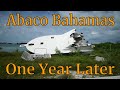 Marsh Harbour, Abaco, Bahamas: One Year After Hurricane Dorian
 Dorian becomes extreme Category 5 hurricane. Where is Dorian going next?
 Hurricane Dorian Eye Wall
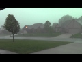 Severe Thunderstorm - May 1, 2012
 Top 5 Fan Voted Tropical Cyclones!
 SSL457 ~ Hurricane GONZALO and CORONAVIRUS... a VERY bad mix..!!
 Anatomy of a Hurricane
 Flying through a Hurricane Eye wall
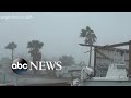 Hurricane Hanna makes landfall in Texas