- Популярные видео
- Авто
- Видео-блоги
- ДТП, аварии
- Для маленьких
- Еда, напитки
- Животные
- Закон и право
- Знаменитости
- Игры
- Искусство
- Комедии
- Красота, мода
- Кулинария, рецепты
- Люди
- Мото
- Музыка
- Мультфильмы
- Наука, технологии
- Новости
- Образование
- Политика
- Праздники
- Приколы
- Природа
- Происшествия
- Путешествия
- Развлечения
- Ржач
- Семья
- Сериалы
- Спорт
- Стиль жизни
- ТВ передачи
- Танцы
- Технологии
- Товары
- Ужасы
- Фильмы
- Шоу-бизнес
- Юмор
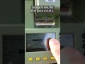
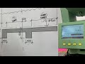
Surveying Techniques with GPS: Creating Lines and Arcs in Real Time
Watch one of our talented students as they undergo assessment using the Leica GS18 GNSS GPS, a step towards achieving the Proqual Level 3 Diploma in Engineering Surveying.
In this video, the learner not only showcases their proficiency with the GPS but also demonstrates how to create lines and set them out.
Our specialized courses provide students with the knowledge and skills needed for success in the world of surveying and engineering.
Ready to pursue the Proqual Level 3 Diploma and unlock a world of opportunities? Visit our website at https://www.finchleycollege.com/surveying-engineering-courses to learn more about our programs and embark on your path to success in engineering surveying. Subscribe to our channel for more content and stay connected with us.
Start your journey with Finchley College today!
For inquiries and additional information, please contact us:
Email: finchleycollege@yahoo.com
Phone: (+44)7974221155
0:00 Surveying Points
1:20 Creating Line
2:13 Setting out from the Line
3:21 Creating Arc
4:04 Setting Out Arc
Видео Surveying Techniques with GPS: Creating Lines and Arcs in Real Time канала Finchley College
Комментарии отсутствуют
Информация о видео
17 декабря 2023 г. 15:00:02
00:05:42
Другие видео канала