Very Intense Severe Thunderstorm - Damaging Squall Line in West Bend, WI - 6/27/19
Please check out my Instagram, where I frequently post pictures of weather and nature as a whole! https://www.instagram.com/jm.smith_/
This line of storms was part of a long lived MCS that developed over eastern Montana on the evening of June 26th. Through the night of June 26-27, the storms barreled across the Dakotas and Minnesota. By mid-morning on the 27th, the storms entered Wisconsin, weakening as they did so. The storms re-intensified by early/mid afternoon as the atmosphere became highly unstable. Just before arriving at my location, the storms' outflow collided with the lake breeze front created by Lake Michigan, causing the storms to intensify further and produce verified hurricane force wind gusts.
The storm had pretty good structure, but that structure did not do justice to just how powerful the storm really was. There were several entire trees down in my neighborhood, as well as many large branches. I apologize for any erratic camera movement in the 2nd half of the video.
Thanks for watching!
Видео Very Intense Severe Thunderstorm - Damaging Squall Line in West Bend, WI - 6/27/19 канала MidwestStormChasing
Показать
Комментарии отсутствуют
Информация о видео
Другие видео канала
 Extreme High Winds & Severe Thunderstorm - West Bend, WI
 This Storm Was Serious 😳⛈🌪 | Weather Vlog Houston, Texas May 18, 2021
 Riding Out The Storm - A Derecho in Wisconsin
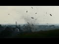 Close Range VIOLENT Tornado Ripping Apart Buildings & Trees - Esmond, IL - 8/9/21
 Severe Thunderstorm Warning - Somerset Wisconsin - June 11th, 2017
 Large Multi-Vortex Tornado, Rapidly Rotating Wall Cloud - Epic Supercell near Waverly, IA - 7/14/21
 15 MOST EXTREME Weather Events Caught on Video
 Orages multicellulaires des 04 & 05 juillet 2012 / Multicell storm of 04 & 05 july 2012
 Cedar Rapids Derecho Live Camera Aug 10, 2020
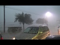 Laredo TX HP-Monster Downburst 21.05.2017
 🌨RAIN & HAIL❄ Storm on a METAL Roof with ⚡THUNDER⚡-12 Hours-Ambient Sounds for SLEEP-Read-RELAX
 Strong Thunderstorm Brings High Winds, Vivid/Nearby Lightning, Loud Thunder - 5/26/20 Rochester, MN
 MONSTER Severe thunderstorms in HD! Ground-dragging shelf clouds - Charleston, WV
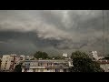 Severe Thunderstorm in Varna + Bonus - 03 August 2019
 derecho storm cedar rapids, ia part 1 (church roof explodes)
 Go to Sleep with Thunder & Rain Sounds | Relaxing Sounds for Insomnia Symptoms & Sleeping Disorders
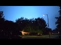 Intense Severe Thunderstorm in Leander/Cedar Park, TX! - 6/4/2018
 July 4th, 2018 Time-Lapse - Severe Afternoon Thunderstorm
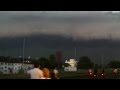 2014-06-09 thunderstorm in Cologne, Mülheim, Germany
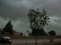 Severe Storm in Texas with Tornado Sirens