Radiometric correction on arcgis 10.5 tutorial 2 || Tekson
I just upload the tutorial for Radiometric Correction. I think this may help you to adjust the data. It contains Radiometric correction, Atmospheric Correction ( sun angle correction, Landsat 7 fixline error).
Landsat data of Kathmandu: https://drive.google.com/open?id=1A42BzoXScvKrkUtXspU5fAcMvfDNxZi3
Download Landsat Toolbox:
https://drive.google.com/open?id=1q8gMewtifJ0sNeflOt00K_KYP14m38FH
Find me on Instagram: https://www.instagram.com/iamtekson/
Find me on GitHub: https://github.com/iamtekson
Видео Radiometric correction on arcgis 10.5 tutorial 2 || Tekson канала GeoDev
Показать
Комментарии отсутствуют
Информация о видео
Другие видео канала
 Radiometric Correction for Satellite image in Arc Map
 Detail method to do Radiometric Atmospheric Correction of Landsat 8 Images using ArcGIS
 Reservoir volume calculation using DEM data in ArcGIS | Tekson
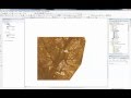 Landsat 8: Atmospheric Correction and Band Rationing Using ArcGIS
 Atmospheric correction of Hyperspectral Imagery using FLAASH in ENVI
 Radiometric Corrections
 v13 extracting spectral signatures in ArcMap
 Envi Radiometric Correction
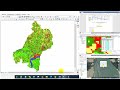 Accuracy Assessment | Kappa Coefficient | User Accuracy| Producer Accuracy| Overall Accuracy
 mosaicing, subsetting and masking raster datasets in SNAP
 Radiometric correction in QGIS
 Shapefile from Google Earth to GIS || Importing Image from Google Earth to GIS
 How to | Convert DN to TOA Reflectance for Landsat-8 | NDVI,NDBI,NDWI,MNDWI,SAVI,MSAVI,NBR,NBR-2
 Radiometric Correction of Landsat Imagery(Sun Elevation) using ArcGIS Software
 Satellite Imagery Clouds Cover Removal in ArcGIS Desktop
 Flaash atmospheric correction Landsat 8 OLI using ENVI 5 2
 TUTORIAL MEMBUAT PETA ADMINISTRASI DENGAN ARCGIS
 How To Join And Relate Excel Sheets To Shapefiles in ArcGis in urdu/hindi || Lecture Number 19
 NASA ARSET: Introduction to Accuracy Assessments, Part 1/2
 Mapping and Geospatial Data Analysis Using MATLAB