- Популярные видео
- Авто
- Видео-блоги
- ДТП, аварии
- Для маленьких
- Еда, напитки
- Животные
- Закон и право
- Знаменитости
- Игры
- Искусство
- Комедии
- Красота, мода
- Кулинария, рецепты
- Люди
- Мото
- Музыка
- Мультфильмы
- Наука, технологии
- Новости
- Образование
- Политика
- Праздники
- Приколы
- Природа
- Происшествия
- Путешествия
- Развлечения
- Ржач
- Семья
- Сериалы
- Спорт
- Стиль жизни
- ТВ передачи
- Танцы
- Технологии
- Товары
- Ужасы
- Фильмы
- Шоу-бизнес
- Юмор
NANO BANANA PRO + GOOGLE EARTH Can Save Architects HOURS of TIME
🔥EXCLUSIVE Realistic floor plan rendering with Nano Banana + Photoshop: https://salmaanmohamed.gumroad.com/l/nanobanananarender
Use 'NANO10' for a Limited time 10% Discount
🔗 Google AI Studio: https://aistudio.google.com/
⌛Timestamps:
00:00 Introduction
00:33 Vector Maps with Google Earth
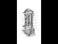
02:36 Street Elevations from Google Earth
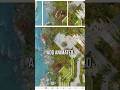
05:31 Aerial views of Remote Locations
06:33 Place Designs on Site
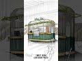
08:12 Separate a building from Image
08:49 Annotate Buildings
In this video, we explore how Nano Banana Pro combined with Google Earth can unlock powerful AI workflows for architects, designers, and urban planners. Learn how to convert Google Earth data into vector maps, CAD files, street elevations, aerial views, and place architectural designs directly on site in seconds.
This workflow simplifies site analysis, architectural visualization, floor plan rendering, and presentation graphics, even for remote locations with limited 3D data. Perfect for architects looking to save time and upgrade their design process using AI.
➡️Follow us:
📷 Instagram: https://www.instagram.com/salmaan.arch/
🔗 Website: https://www.salmaanmohamed.com/
👍🏻Like this video if you found it helpful
🔔 Subscribe for more Architectural tips, tools, and workflow hacks
💬 Drop a comment and let us know which feature you're most excited to try!
_______
#NanoBananaPro #VideoGeneration #AIVideo
Видео NANO BANANA PRO + GOOGLE EARTH Can Save Architects HOURS of TIME канала Salmaan Mohamed
Use 'NANO10' for a Limited time 10% Discount
🔗 Google AI Studio: https://aistudio.google.com/
⌛Timestamps:
00:00 Introduction
00:33 Vector Maps with Google Earth
02:36 Street Elevations from Google Earth
05:31 Aerial views of Remote Locations
06:33 Place Designs on Site
08:12 Separate a building from Image
08:49 Annotate Buildings
In this video, we explore how Nano Banana Pro combined with Google Earth can unlock powerful AI workflows for architects, designers, and urban planners. Learn how to convert Google Earth data into vector maps, CAD files, street elevations, aerial views, and place architectural designs directly on site in seconds.
This workflow simplifies site analysis, architectural visualization, floor plan rendering, and presentation graphics, even for remote locations with limited 3D data. Perfect for architects looking to save time and upgrade their design process using AI.
➡️Follow us:
📷 Instagram: https://www.instagram.com/salmaan.arch/
🔗 Website: https://www.salmaanmohamed.com/
👍🏻Like this video if you found it helpful
🔔 Subscribe for more Architectural tips, tools, and workflow hacks
💬 Drop a comment and let us know which feature you're most excited to try!
_______
#NanoBananaPro #VideoGeneration #AIVideo
Видео NANO BANANA PRO + GOOGLE EARTH Can Save Architects HOURS of TIME канала Salmaan Mohamed
architecture architect architectural design architecture school ai prome ai artificial intelligence mid journey ai prome ai tutorial ai art ai art generator midjourney ai architecture ai architecture design architecture student architecture life design midjourneyai lookx aiart aiarchitecture chatgpt chargptrender rendertutorial airilab promeai nanobanana nanobananatutorial geminiai googleai runway runwayai runwayaleph aleph videoediting architecturewalkthrough
Комментарии отсутствуют
Информация о видео
24 декабря 2025 г. 23:13:59
00:09:57
Другие видео канала