Webinar: Popular UAV LiDAR Use Cases
The Phoenix LiDAR Team discusses three popular applications for UAV LiDAR:
1) Disaster Response
2) High Precision Infrastructure Monitoring
3) Challenging Topographic Surveying.
They'll discuss the initial challenge, the drone LiDAR scan, and the resulting 3D point cloud.
Apologies for the obstruction on the right side of the screen. We'll find the setting to turn off that admin panel for the next webinar!
Subscribe and Follow us:
Facebook: https://www.facebook.com/PhoenixLiDAR/
Twitter: https://twitter.com/phoenixlidar
Instagram: https://www.instagram.com/phoenixlidar/
Learn more about us at www.phoenixlidar.com
Видео Webinar: Popular UAV LiDAR Use Cases канала Phoenix LiDAR
Показать
Комментарии отсутствуют
Информация о видео
Другие видео канала
 Drone LiDAR REVIEW | LiAirV | DJI LiVOX
 What is Precision Agriculture? What is the meaning of Precision Farming?
 The Superiority of Digital Automotive Lidar Sensors
 REDD+ Learning Session 60: Estimating Forest Biomass using LiDAR Clouds
 Fundamentals of Drone LiDAR
 Drone Deploy Mapping Demo Tutorial | DJI Mavic Pro
 Phoenix LiDAR Flight Planner
 Five Secrets to Selecting a Drone LiDAR System
 Getting Started with LIDAR
 Forest Applications of LiDar
 LIDAR Mag Webinar: Single Photon LIDAR - Why Not See the Forest AND the Trees?
 Top tips for starting your drone business in 2020
 Calculating a Stockpile Volume from Point Cloud Data using Civil 3D
 Webinar: How drone surveying can improve your earthwork estimations & worksite productivity
 Webinar: Real-Time Mission Guidance for Manned LiDAR Acquisition
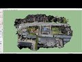 How to create 3D environment models from drone images
 Aerobotics Drone Partners Webinar
 iPhone 12 Pro LIDAR Sensor - INCREDIBLE FAST 3D Scanner!
 UAV-America Agricultural Use of Drones - Case Study
 LiDAR Drone Powerline Inspection | ROCK R2A | DJI M210