- Популярные видео
- Авто
- Видео-блоги
- ДТП, аварии
- Для маленьких
- Еда, напитки
- Животные
- Закон и право
- Знаменитости
- Игры
- Искусство
- Комедии
- Красота, мода
- Кулинария, рецепты
- Люди
- Мото
- Музыка
- Мультфильмы
- Наука, технологии
- Новости
- Образование
- Политика
- Праздники
- Приколы
- Природа
- Происшествия
- Путешествия
- Развлечения
- Ржач
- Семья
- Сериалы
- Спорт
- Стиль жизни
- ТВ передачи
- Танцы
- Технологии
- Товары
- Ужасы
- Фильмы
- Шоу-бизнес
- Юмор
NDWI, NDBI, SAVI & EVI Explained + Calculated in PyQGIS | Remote Sensing Indices
📡 What if I told you that with just TWO satellite bands and ONE formula, you can
map all the water bodies in a region? Or detect urban sprawl? Or measure crop
stress? That's the power of Remote Sensing Indices — and in Day 10, we cover FOUR
of them!
📌 What You'll Learn:
✅ What Remote Sensing Indices are — and why they outperform raw band values
✅ NDWI (Water Index) — formula, physics, and PyQGIS code
✅ NDBI (Built-up Index) — how to detect cities from satellite imagery
✅ SAVI (Soil-Adjusted Vegetation Index) — fixing NDVI for sparse vegetation
✅ EVI (Enhanced Vegetation Index) — NASA's improvement for dense forests &
atmosphere
✅ When to use NDVI vs SAVI vs EVI — a clear decision guide
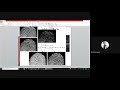
✅ Step-by-step Python code for NDWI, NDBI, and SAVI in PyQGIS
✅ Real-world applications: flood mapping, urban sprawl, drought, precision
agriculture
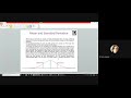
📊 Formulas Covered:- NDWI = (Green − NIR) / (Green + NIR) → Landsat Bands 3 & 5- NDBI = (SWIR − NIR) / (SWIR + NIR) → Landsat Bands 6 & 5- SAVI = [(NIR − Red) / (NIR + Red + L)] × (1 + L) → L = 0.5- EVI = 2.5 × (NIR − Red) / (NIR + 6×Red − 7.5×Blue + 1)
⏱ Timestamps:
00:00 – Introduction
00:45 – What Are Remote Sensing Indices?
02:30 – Categories of Indices
03:15 – NDWI: Water Index
05:00 – NDBI: Built-up Index
06:30 – SAVI: Soil-Adjusted Vegetation Index
08:15 – EVI: Enhanced Vegetation Index
10:00 – Calculating NDWI in PyQGIS
#NDWI #NDBI #SAVI #EVI #PyQGIS #RemoteSensing #SatelliteImagery #Landsat
#PythonGIS
Видео NDWI, NDBI, SAVI & EVI Explained + Calculated in PyQGIS | Remote Sensing Indices канала Learn Computer Science with Prof. Rashi
map all the water bodies in a region? Or detect urban sprawl? Or measure crop
stress? That's the power of Remote Sensing Indices — and in Day 10, we cover FOUR
of them!
📌 What You'll Learn:
✅ What Remote Sensing Indices are — and why they outperform raw band values
✅ NDWI (Water Index) — formula, physics, and PyQGIS code
✅ NDBI (Built-up Index) — how to detect cities from satellite imagery
✅ SAVI (Soil-Adjusted Vegetation Index) — fixing NDVI for sparse vegetation
✅ EVI (Enhanced Vegetation Index) — NASA's improvement for dense forests &
atmosphere
✅ When to use NDVI vs SAVI vs EVI — a clear decision guide
✅ Step-by-step Python code for NDWI, NDBI, and SAVI in PyQGIS
✅ Real-world applications: flood mapping, urban sprawl, drought, precision
agriculture
📊 Formulas Covered:- NDWI = (Green − NIR) / (Green + NIR) → Landsat Bands 3 & 5- NDBI = (SWIR − NIR) / (SWIR + NIR) → Landsat Bands 6 & 5- SAVI = [(NIR − Red) / (NIR + Red + L)] × (1 + L) → L = 0.5- EVI = 2.5 × (NIR − Red) / (NIR + 6×Red − 7.5×Blue + 1)
⏱ Timestamps:
00:00 – Introduction
00:45 – What Are Remote Sensing Indices?
02:30 – Categories of Indices
03:15 – NDWI: Water Index
05:00 – NDBI: Built-up Index
06:30 – SAVI: Soil-Adjusted Vegetation Index
08:15 – EVI: Enhanced Vegetation Index
10:00 – Calculating NDWI in PyQGIS
#NDWI #NDBI #SAVI #EVI #PyQGIS #RemoteSensing #SatelliteImagery #Landsat
#PythonGIS
Видео NDWI, NDBI, SAVI & EVI Explained + Calculated in PyQGIS | Remote Sensing Indices канала Learn Computer Science with Prof. Rashi
NDWI NDBI SAVI EVI remote sensing indices NDWI formula NDBI formula SAVI formula EVI formula PyQGIS NDWI PyQGIS NDBI PyQGIS SAVI water index satellite built-up index soil adjusted vegetation index enhanced vegetation index Landsat bands NDVI vs SAVI vs EVI vegetation index urban mapping satellite water body detection satellite flood mapping NDWI EVI NASA MODIS dense forest EVI atmospheric correction EVI SWIR NIR Landsat 8 indices
Комментарии отсутствуют
Информация о видео
18 мая 2026 г. 20:20:25
00:17:06
Другие видео канала