Hunting for distribution valves with augmented reality
Using vGIS Utilities (www.vGIS.io) to hunt for distribution valves (gotta catch 'em all). In this instance, vGIS is running on iPhone 6S without any external hardware, using only vGIS's proprietary calibration and stabilization algorithms. The base GIS data quality was +/- 30cm, and vGIS managed to accurately point the valves with the +/-10cm accuracy. Minor visuals misalignments are due to the 3D perspective.
vGIS Utilities is the most advanced augmented reality solution for Esri GIS. vGIS was designed specifically with utilities, municipalities and service providers in mind to create a more productive, enjoyable and safe working environment. The system connects to Esri ArcGIS to seamlessly convert traditional 2D GIS data into powerful, accurate and stable 3D visuals. vGIS Utilities is deployed at over 40 sites across the world to bring real-life benefits to its users. More at http://www.vgis.io/.
Видео Hunting for distribution valves with augmented reality канала vGIS Inc.
Показать
Комментарии отсутствуют
Информация о видео
Другие видео канала
 Viewing Complex Systems With AR
 Avoid Rework with 3D Reality Capture and vSite
 Make the Most Out of Your Project-Critical Data
 Augmented Reality (AR) for Esri ArcGIS GIS - CAD-quality visuals
 Engineering-grade augmented reality for construction
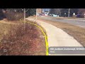 Locate job - QA checks with vGIS
 High-accuracy engineering grade augmented reality for construction
 Reality mesh (reality capture/context capture) visualized with high-accuracy augmented reality (AR)
 Earthworks visualization in engineering-grade augmented reality AR
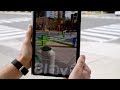 vGIS - Le système de réalité augmentée le plus avancé pour SIG et BIM
 Happy Holidays from vGIS (with some Augmented Reality)
 GIS and augmented reality - Utility locates in winter
 Augmented reality ‘sticky notes’ - vGIS Tags
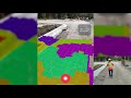 Documenting construction with engineering-grade augmented reality AR
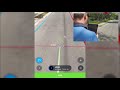 GIS data collection with Augmented Reality
 Make IoT Sensor Data Easily Accessible
 vSite: 3D Documentation on the Job Site
 Subsurface engineering (SUE) and Augmented Reality
 Scan-to-BIM: viewing BIM assets stored in ArcGIS in MS HoloLens
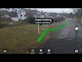 GPR scan to AR workflow