An Overview of Aerial Mapping with Pixhawk, Pix4D, and GoPro Hero3+
As I got further into producing this video I realized just how much information there is related to producing your own aerial maps. I touch on this from a high-level, but plan on doing a more in-depth series of videos soon.
Here are the aerial maps from the video that I'll be updating with new layers as I produce them from my UAV:
http://bit.ly/1w9DumJ
Here are the GoPro photos, telemetry log, and Pix4D output from my flight that day:
http://bit.ly/1F0lb9I
GoPro Hero 3+:
http://amzn.to/1fLgQKU
Be sure to check out Pix4D:
http://bit.ly/1wL9HRi
Here's a link to QGIS:
http://bit.ly/1sKJsLz
and finally here's a link to gdal2tiles that I use to create the map tiles to be overlaid on Google Maps:
http://bit.ly/1rdjzPz
I hope this is useful information. Please feel free to post any questions or comments below.
Thanks for watching!
Видео An Overview of Aerial Mapping with Pixhawk, Pix4D, and GoPro Hero3+ канала Dennis Baldwin
Показать
Комментарии отсутствуют
Информация о видео
Другие видео канала
 Quick Update on 3D Printed Downward Facing Gimbal for Aerial Mapping
 How to get accuracy in Drone / UAS Mapping with Pix4D: What You Need to Know
 Ortho Mapping: Transforming Raw Imagery into Authoritative Content for GIS
 First Flight! Tarot 650 Sport Extended Arm Drone with Pixhawk 4 (Awesome Flight Time!)
 Arduplane auto-takeoff and auto-land test
 How to Setup Distance Based Shutter with APM 2.6, CHDK and Canon SX260 HS
 A Drone Mappers Guide to All the Equipment You Need for Precise Drone Mapping
 20 Classic Vehicles that Defined an Era including a 1953 Boat Car
 Arduino CNC Foam Cutting Machine (Complete Guide)
 Common PixHawk Setup Problems and How to Avoid Them!
 Agisoft Photoscan: Generating Orthomosaics from Aerial Photography
 Construction - Progress Reports with Drone Mapping
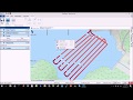 Mapping a Lake with ArduPilot
 What is the Best Drone for Mapping?
 Photogrammetry/Drone Mapping mistakes you should avoid.
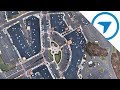 How to Create a 2D Map with Your Drone Using DroneDeploy
 Pixhawk Gimbal Setup. Fast And Easy!
 Nimbus VTOL Mapping and Image Processing
 PixHawk AUX Outputs Setup for 14 Channels, Taranis X9D, X8R Receiver
 PixHawk and APM Mapping Camera Configuration