Map projection, coordinate system and datum
Subject: Geology
Paper: Remote sensing and GIS
Module: Map projection, coordinate system and datum
Content Writer: Asif
Видео Map projection, coordinate system and datum канала Vidya-mitra
Paper: Remote sensing and GIS
Module: Map projection, coordinate system and datum
Content Writer: Asif
Видео Map projection, coordinate system and datum канала Vidya-mitra
Показать
Комментарии отсутствуют
Информация о видео
Другие видео канала
 Intro to coordinate systems and UTM projection
 Map projections in GIS (theory)
 Coordinate System Jargon: geoid, datum, projection
 A Simple Explanation of Datum
 Map Projections Part 1: General Information & Cylindrical Projections
 Different map projections
 Classification of Map Projection: Area,Shape & Distance; Light - Stereographic,Orthographic&Gnomonic
 gis (geographic information systems ) | introduction to gis | lecture 1
 What are Geodetic Datums?
 Flexible Manufacturing System (Fms)(हिन्दी )
 Understanding Coordinate Systems and Projections for ArcGIS
 मानचित्र प्रक्षेप एवं उनका वर्गीकरण ( Map Projection and Their Classification)
 Introducing Coordinate Systems and Transformations
 Projections in GIS (in Hindi)
 Tissot's Indicatrix
 Map Projections Explained - A Beginners Guide
 Lecture; Maps, Maps, Maps The Basics of Cartography
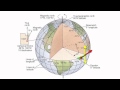 Latitude & Longitude
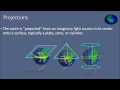 Geographic Datums and Projections in HINDI