Boring Through The Earth's Crust
Over the course of the 1960s into the 80s, several interdisciplinary geoscientific research projects such as the Upper Mantle Project, the Geodynamics Project, and the Deep Sea Drilling Project, contributed significantly to a better understanding of the earth's structure and development. In the 1960s, several prominent research organizations such as the National Academy of Sciences and the Ministry of Geology of the USSR initiated exploratory programs that used deep drilling to study the internals of the Earth. The aim of the program was to develop a model of the Earth’s crust and upper mantle, as well as new methods for forecasting mineral deposits. It developed a fundamentally new technical approach to the study of the deep structure of the Earth’s crust and upper mantle, based on a combination of seismic depth-sensing, deep drilling data, and other geophysical and geochemical methods.
These studies resulted in technologies that advanced both super-deep drilling and geological logging, in boreholes over 10 km deep.
DRILLING
In cable-tool drilling each drop would transmit force through a series of heavy iron drilling columns known as strings, driving a variety of bits deep into the borehole. Rotary drills utilized a hollow drill stem, enabling broken rock debris to be circulated out of the borehole, along with mud, as the rotating drill bit cut deeper.
PROJECT MOHOLE
The project’s goal was to drill through the Earth’s crust to retrieve samples from the boundary between the earth's crust and the mantle, known as the Mohorovicic discontinuity or Moho. Planned as a multi-hole, three-phase project, it would ultimately achieve a drill depth of 183 meters under the pacific seafloor, at a depth of 3.6 km. Despite Project Mohole’s failure in achieving its intended purpose, it did show that deep-ocean drilling was a viable means of obtaining geological samples.
USSR'S RESPONSE
The Kola Superdeep Borehole had a target depth set at 15,000 meters, and in 1979, it had surpassed the 9,583-meter vertical depth record held by the Bertha Rogers hole, a failed oil-exploratory hole drilled in Washita County, Oklahoma, in 1974. By 1984, the Soviets had reached a depth of over 12,000 meters. Drilling would later restart from 7,000 meters. Finally, in 1989, after grinding through crystalline rock for more than half its journey, the drill bit reached a final reported depth of 12,262 meters, the deepest artificial point on Earth.
Though this fell short of the projected 1990 goal of 13,500 meters, drilling efforts continued despite technical challenges. However, in 1992, the target of 15,0000 meters was eventually deemed impossible after the temperatures at the hole’s bottom, previously expected to reach only 100 degrees C, was measured at over 180 degrees C. Ultimately, the dissolution of the Soviet Union led to the abandonment of the borehole in 1995. The Kola Superdeep Borehole was surpassed, in length only, by the slant drilled Al Shaheen oil well in Qatar, which extended 12,289 meters, though with a horizontal reach of 10,902 meters.
HOW IT WAS DRILLED
A 215mm diameter bit was rotated by a downhole turbine that was powered by the hydraulic pressure of ground-level mud pumps. A downhole instrument consisting of a generator, a pulsator, and a downhole measuring unit that measures the navigation and geophysical parameters were fitted to the drill. The pulsator converts the measured data into pressure pulses that propagate through the fluid barrel in the drilling tool and are received by pressure sensors at the surface. At the surface, the signal received by pressure sensors is sent to the receiving device, where it is amplified, filtered, and decoded for control and recording use.
The downhole instrument is powered by the generator, which uses the movement of flushing fluid as a power source.
WHAT WAS FOUND
Rock samples taken from the borehole exposed cycles of crust-building that brought igneous rock into the crust from the mantle below. Additionally, one of the primary objectives of the Kola well was to penetrate through the upper layer of granite into the underlying basaltic rock. Even more astonishing, was the discovery of a subterranean layer of marine deposits, almost 7,000 meters beneath the surface, that were dated at two billion years old, and contained the fossil traces of life from 24 different species of plankton.
Similar projects have taken place since the drilling of the Kola Superdeep borehole. One such notable example was the German Continental Deep Drilling Program, which was carried out between 1987 and 1995, reaching a depth of over 9,000 meters and using one of the largest derricks in the world. From this, the drilling project San Andreas Fault Observatory at Depth or SOFAD was formed in 2002.
SUPPORT NEW MIND ON PATREON
https://www.patreon.com/newmind
SOCIAL MEDIA LINKS
Instagram - https://www.instagram.com/newmindchannel
Видео Boring Through The Earth's Crust канала New Mind
Показать
Комментарии отсутствуют
Информация о видео
Другие видео канала
 The Science Of Boost
 The Mystery Of Paperclips
 The World Of Microscopic Machines
 The Science Of Darkness: Pigments, The Cosmos and Nanotechnology
 The Evolution Of Stealth Technology
 The Evolution Of Music Storage
 The Evolution Of Cutting Tools
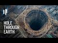 What If You Drilled a Hole Through Earth?
 The Story Of Large Vessel Engines
 The Mechanical Battery
 Clever Uses Of Thermal Expansion
 15 Oldest Technologies That Scientists Can't Explain
 The Story Of Electric Vehicle Batteries
 In Flight Refueling
 The Illusion Of Digital Audio
 The Spark Plug Story
 The Science Of Small Distances
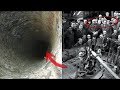 Here's What is at the Bottom of the Deepest Hole on Earth...
 Extreme Materials