Getting to Know the Utility Network
The Utility Network is a beta feature of ArcGIS that introduces new capabilities to deliver, manage and analyze utility networks across the ArcGIS platform. This webinar will provide an introductory overview of the Utility Network and the tools used to configure a network for water, sewer and stormwater utilities. Learn more at http://go.esri.com/utilitynetwork.
Видео Getting to Know the Utility Network канала Esri Industries
Видео Getting to Know the Utility Network канала Esri Industries
Показать
Комментарии отсутствуют
Информация о видео
Другие видео канала
 Esri's Utility Network - Understanding the Impact and Planning the Journey
 7 Steps to Getting Started with the ArcGIS Utility Network
 ArcMap vs ArcGIS Pro - Comparing these two GIS applications from Esri
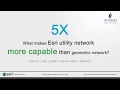 Esri’s Utility Network vs. Geometric Network: A Technical Comparison
 The UK Digital Water Utility Experience
 ArcGIS 10.2 Water Utility Network Editing
 ArcGIS StoryMaps: Getting Started with the New Story Builder
 Insight into the Utility Network
 How Water Towers Work
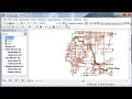 Quickest or Shortest Route Within Network
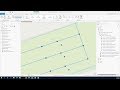 Introduction to the Utility Network for Water Utilities
 Overview of the Trace Network in ArcGIS Pro 2.6
 Pipeline Data Management on PODS 7.0
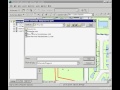 Introduction to ArcGIS Schematics
 Network Management with ArcGIS - Introduction to the Utility Network
 Esri Utility Network Electric Tracing
 Deep Dive into Machine Learning in ArcGIS Platform
 Fundamental GIS Terms and Concepts
 Introduction to the ArcGIS Utility Network for All Industries