- Популярные видео
- Авто
- Видео-блоги
- ДТП, аварии
- Для маленьких
- Еда, напитки
- Животные
- Закон и право
- Знаменитости
- Игры
- Искусство
- Комедии
- Красота, мода
- Кулинария, рецепты
- Люди
- Мото
- Музыка
- Мультфильмы
- Наука, технологии
- Новости
- Образование
- Политика
- Праздники
- Приколы
- Природа
- Происшествия
- Путешествия
- Развлечения
- Ржач
- Семья
- Сериалы
- Спорт
- Стиль жизни
- ТВ передачи
- Танцы
- Технологии
- Товары
- Ужасы
- Фильмы
- Шоу-бизнес
- Юмор
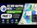
Build a COMPLETE Population Web Map with React Leaflet | Fetch GeoJSON Data
In this tutorial, you’ll learn how to build a web mapping application using React Leaflet, focusing on creating an interactive choropleth map by fetching GeoJSON data.
This video walks you through the complete workflow of Web GIS development, including loading GeoJSON data, styling map layers dynamically, and visualizing spatial data using color scales.
What you’ll learn in this video:
1. How to set up a React Leaflet web mapping application
2. How to fetch GeoJSON data from the public folder
3. How to create a choropleth map in React Leaflet
4. Styling polygons based on attribute values
5. Adding interactivity to GeoJSON layers
6. Best practices for web mapping and GIS applications
This tutorial is ideal for:
GIS Developers
Web Mapping beginners
React & JavaScript developers
Anyone learning Geospatial Web Development
Technologies used include;
React.js
React Leaflet
GeoJSON
JavaScript
Web GIS concepts
If you’re interested in GIS programming, web mapping, or building interactive maps, this video is part of a broader series on modern GIS web development.
Don’t forget to like, subscribe, and comment if you found this helpful!
Udemy Course: https://www.udemy.com/course/google-earth-engine-supervised-classification-for-lulc/?referralCode=952B5F2605AB7C9EB282
GitHub: https://github.com/MicahSifuna/choropleth-map
React Leaflet: https://react-leaflet.js.org/docs/start-setup/
Python video for joining spatial data: https://www.youtube.com/watch?v=E8iUTMJEbDU
Видео Build a COMPLETE Population Web Map with React Leaflet | Fetch GeoJSON Data канала GIS Developer
react leaflet choropleth map web mapping gis web development react leaflet tutorial geojson tutorial fetch geojson react choropleth map react web gis gis programming geospatial development react gis leaflet choropleth interactive maps javascript gis mapping application web map tutorial react js mapping leaflet geojson spatial data visualization gis dev geospatial web mapping frontend gis react leaflet course
Комментарии отсутствуют
Информация о видео
9 января 2026 г. 19:30:51
01:51:09
Другие видео канала