- Популярные видео
- Авто
- Видео-блоги
- ДТП, аварии
- Для маленьких
- Еда, напитки
- Животные
- Закон и право
- Знаменитости
- Игры
- Искусство
- Комедии
- Красота, мода
- Кулинария, рецепты
- Люди
- Мото
- Музыка
- Мультфильмы
- Наука, технологии
- Новости
- Образование
- Политика
- Праздники
- Приколы
- Природа
- Происшествия
- Путешествия
- Развлечения
- Ржач
- Семья
- Сериалы
- Спорт
- Стиль жизни
- ТВ передачи
- Танцы
- Технологии
- Товары
- Ужасы
- Фильмы
- Шоу-бизнес
- Юмор
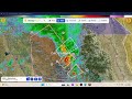
2 Severe Thuderstorm Warning Double Header EAS From KLOE-FM 5/16/26
The National Weather Service in Goodland has issued a
* Severe Thunderstorm Warning for...
Northern Cheyenne County in northwestern Kansas...
Dundy County in southwestern Nebraska...
* Until 645 PM MDT/745 PM CDT/.
* At 556 PM MDT/656 PM CDT/, severe thunderstorms were located along
a line extending from 12 miles northeast of Wray to 6 miles
northeast of Haigler to 10 miles north of St. Francis, moving
northeast at 45 mph.
HAZARD...60 mph wind gusts and quarter size hail.
SOURCE...Radar indicated.
IMPACT...Hail damage to vehicles is expected. Expect wind damage
to roofs, siding, and trees.
* Locations impacted include...
Benkelman.
PRECAUTIONARY/PREPAREDNESS ACTIONS...
For your protection move to an interior room on the lowest floor of a
building.
The National Weather Service in Goodland has issued a
* Severe Thunderstorm Warning for...
Southeastern Thomas County in northwestern Kansas...
* Until 730 PM CDT.
* At 656 PM CDT, a severe thunderstorm was located 9 miles southeast
of Levant, moving northeast at 30 mph.
HAZARD...Two inch hail and 60 mph wind gusts.
SOURCE...Radar indicated.
IMPACT...People and animals outdoors will be injured. Expect hail
damage to roofs, siding, windows, and vehicles. Expect
wind damage to roofs, siding, and trees.
* This severe thunderstorm will be near...
Colby around 705 PM CDT.
This includes Interstate 70 in Kansas between mile markers 52 and 65.
PRECAUTIONARY/PREPAREDNESS ACTIONS...
For your protection move to an interior room on the lowest floor of a
building.
Видео 2 Severe Thuderstorm Warning Double Header EAS From KLOE-FM 5/16/26 канала South Central Kansas WX
* Severe Thunderstorm Warning for...
Northern Cheyenne County in northwestern Kansas...
Dundy County in southwestern Nebraska...
* Until 645 PM MDT/745 PM CDT/.
* At 556 PM MDT/656 PM CDT/, severe thunderstorms were located along
a line extending from 12 miles northeast of Wray to 6 miles
northeast of Haigler to 10 miles north of St. Francis, moving
northeast at 45 mph.
HAZARD...60 mph wind gusts and quarter size hail.
SOURCE...Radar indicated.
IMPACT...Hail damage to vehicles is expected. Expect wind damage
to roofs, siding, and trees.
* Locations impacted include...
Benkelman.
PRECAUTIONARY/PREPAREDNESS ACTIONS...
For your protection move to an interior room on the lowest floor of a
building.
The National Weather Service in Goodland has issued a
* Severe Thunderstorm Warning for...
Southeastern Thomas County in northwestern Kansas...
* Until 730 PM CDT.
* At 656 PM CDT, a severe thunderstorm was located 9 miles southeast
of Levant, moving northeast at 30 mph.
HAZARD...Two inch hail and 60 mph wind gusts.
SOURCE...Radar indicated.
IMPACT...People and animals outdoors will be injured. Expect hail
damage to roofs, siding, windows, and vehicles. Expect
wind damage to roofs, siding, and trees.
* This severe thunderstorm will be near...
Colby around 705 PM CDT.
This includes Interstate 70 in Kansas between mile markers 52 and 65.
PRECAUTIONARY/PREPAREDNESS ACTIONS...
For your protection move to an interior room on the lowest floor of a
building.
Видео 2 Severe Thuderstorm Warning Double Header EAS From KLOE-FM 5/16/26 канала South Central Kansas WX
Комментарии отсутствуют
Информация о видео
17 мая 2026 г. 5:12:52
00:02:56
Другие видео канала