- Популярные видео
- Авто
- Видео-блоги
- ДТП, аварии
- Для маленьких
- Еда, напитки
- Животные
- Закон и право
- Знаменитости
- Игры
- Искусство
- Комедии
- Красота, мода
- Кулинария, рецепты
- Люди
- Мото
- Музыка
- Мультфильмы
- Наука, технологии
- Новости
- Образование
- Политика
- Праздники
- Приколы
- Природа
- Происшествия
- Путешествия
- Развлечения
- Ржач
- Семья
- Сериалы
- Спорт
- Стиль жизни
- ТВ передачи
- Танцы
- Технологии
- Товары
- Ужасы
- Фильмы
- Шоу-бизнес
- Юмор
3D Modelling with the South INNO8: Visual RTK GNSS Workflow
See the South INNO8 Visual RTK GNSS Rover here:
https://globalgpssystems.com/south-inno8-rover-set-visual-rtk-gnss-with-imu/
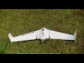
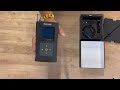
In this video, we look at 3D modelling with the South INNO8 Rover Set, a professional Visual RTK GNSS rover with IMU tilt compensation designed for surveyors, construction teams, GIS users, and drone mapping crews.
The South INNO8 supports visual positioning, image-based measurement, photogrammetry, AR stakeout, and RTK GNSS workflows, making it useful for capturing site details that can support 3D modelling projects. It can help collect ground images and coordinates that may be combined with UAV data or third-party modelling software, especially in areas drones may miss, such as façades, under structures, around vegetation, road edges, and restricted visibility zones.
With 60° IMU tilt compensation, an 8 MP visual positioning camera, multi-constellation GNSS tracking, integrated 4G, WiFi, Bluetooth, NFC, and UHF radio, the INNO8 is built for demanding survey and construction fieldwork. It is suitable for topographic surveys, construction layout, as-built checks, UAV ground support, infrastructure projects, and 3D modelling workflows.
If you want a modern GNSS rover that combines RTK accuracy, visual measurement, tilt surveying, and 3D modelling support, the South INNO8 is worth checking out.
Get the South INNO8 Rover Set here:
https://globalgpssystems.com/south-inno8-rover-set-visual-rtk-gnss-with-imu/
If you found value, hit like & subscribe!
Comment below: Would you use the South INNO8 for 3D modelling, drone mapping, or traditional surveying?
Видео 3D Modelling with the South INNO8: Visual RTK GNSS Workflow канала Global GPS Systems
https://globalgpssystems.com/south-inno8-rover-set-visual-rtk-gnss-with-imu/
In this video, we look at 3D modelling with the South INNO8 Rover Set, a professional Visual RTK GNSS rover with IMU tilt compensation designed for surveyors, construction teams, GIS users, and drone mapping crews.
The South INNO8 supports visual positioning, image-based measurement, photogrammetry, AR stakeout, and RTK GNSS workflows, making it useful for capturing site details that can support 3D modelling projects. It can help collect ground images and coordinates that may be combined with UAV data or third-party modelling software, especially in areas drones may miss, such as façades, under structures, around vegetation, road edges, and restricted visibility zones.
With 60° IMU tilt compensation, an 8 MP visual positioning camera, multi-constellation GNSS tracking, integrated 4G, WiFi, Bluetooth, NFC, and UHF radio, the INNO8 is built for demanding survey and construction fieldwork. It is suitable for topographic surveys, construction layout, as-built checks, UAV ground support, infrastructure projects, and 3D modelling workflows.
If you want a modern GNSS rover that combines RTK accuracy, visual measurement, tilt surveying, and 3D modelling support, the South INNO8 is worth checking out.
Get the South INNO8 Rover Set here:
https://globalgpssystems.com/south-inno8-rover-set-visual-rtk-gnss-with-imu/
If you found value, hit like & subscribe!
Comment below: Would you use the South INNO8 for 3D modelling, drone mapping, or traditional surveying?
Видео 3D Modelling with the South INNO8: Visual RTK GNSS Workflow канала Global GPS Systems
south inno8 rover south inno8 3d modelling 3d modelling with gnss 3d modelling surveying visual rtk gnss visual surveying visual positioning gnss photogrammetry gnss gnss photogrammetry rtk gnss rover gnss rover rtk rover south gnss south gps land surveying equipment surveying equipment survey rover gnss surveying rtk surveying imu tilt compensation gnss with imu drone mapping topographic survey construction layout global gps systems
Комментарии отсутствуют
Информация о видео
21 мая 2026 г. 16:57:53
00:03:45
Другие видео канала