Measure what you see with Leica GS18 I
Leica GS18 I is a versatile, survey-grade GNSS RTK rover with Visual Positioning. Designed for surveying professionals to measure points which previously could not be measured with a GNSS rover easily and accurately. You don't have to worry about obstructed or inaccessible point. You can quickly capture the site in images and measure points from them, either in the field or later in the office.
Видео Measure what you see with Leica GS18 I канала Leica Geosystems AG
Видео Measure what you see with Leica GS18 I канала Leica Geosystems AG
Показать
Комментарии отсутствуют
Информация о видео
Другие видео канала
 HxGN LIVE 2014 Geosystems Keynote "Dirt, Diamonds and Data"
 Leica Rugby 800-series construction lasers
 LEICA 2011 FINAL QT Low Quality
 HxGN SmartNet – Comment ça marche
 Leica Lino L6G und DISTO™ D2 - Die Aufmaßlösung für Brandschutz
 Teodoliten are working more efficiently with the Leica Geosystems automated monitoring solutions
 Leica Machine Control quick tip: How to setup autostationing
 How to setup and demonstrate the PA 80 solution
 Introduction to Public Safety, Security and Forensics solutions at Leica Geosystems, part of Hexagon
 HxGN SmartNet Global
 Leica Zeno FLX100 plus Quick Guide VID 0622
 Quick Tip: How to setup a project in MC1
 Reasons for working at Leica Geosystems, part of Hexagon
 How does machine control work
 How to save 5 minutes per pile with an integrated piling solution?
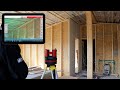 Leica 3D Disto: Wie misst man manuell?
 Leica BLK3D Desktop - 3D-Modellierung und CAD-Export
 Leica Geosystems PowerSnap Solution
 Leica Nova Launch #HxGNLIVE
 Real-Time Surface Logging: Unleashing Cutting-Edge Technology
 Using dual TPS