- Популярные видео
- Авто
- Видео-блоги
- ДТП, аварии
- Для маленьких
- Еда, напитки
- Животные
- Закон и право
- Знаменитости
- Игры
- Искусство
- Комедии
- Красота, мода
- Кулинария, рецепты
- Люди
- Мото
- Музыка
- Мультфильмы
- Наука, технологии
- Новости
- Образование
- Политика
- Праздники
- Приколы
- Природа
- Происшествия
- Путешествия
- Развлечения
- Ржач
- Семья
- Сериалы
- Спорт
- Стиль жизни
- ТВ передачи
- Танцы
- Технологии
- Товары
- Ужасы
- Фильмы
- Шоу-бизнес
- Юмор
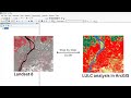
LST from Landsat 8 in Google Earth Engine | Landsat 8 Land Surface Temperature (GEE)
In this tutorial, we calculate LST from Landsat 8 in Google Earth Engine (GEE) using Landsat 8 Level-2 surface temperature data (ST_B10 band). This Landsat 8 Land Surface Temperature (LST) in Google Earth Engine tutorial explains how to filter Landsat 8 imagery by date and area of interest, apply scale and offset values to convert digital numbers into real temperature values in Celsius, and compute monthly mean Land Surface Temperature from Landsat 8 in Google Earth Engine. We also demonstrate how to handle empty image collections, print LST results in the console, and prepare Landsat 8 LST data for visualization and export. This Google Earth Engine LST tutorial is useful for beginners and researchers working on urban heat island analysis, climate studies, and environmental monitoring using Landsat 8 and Google Earth Engine.
Видео LST from Landsat 8 in Google Earth Engine | Landsat 8 Land Surface Temperature (GEE) канала GIS with Raja Usama
Видео LST from Landsat 8 in Google Earth Engine | Landsat 8 Land Surface Temperature (GEE) канала GIS with Raja Usama
LST from Landsat 8 in Google Earth Engine Landsat 8 LST Land Surface Temperature GEE Google Earth Engine LST tutorial Landsat Level 2 LST Landsat 8 surface temperature GEE Land Surface Temperature Landsat 8 GEE Monthly LST from Landsat 8 GEE Landsat 8 Level 2 LST GEE landsat 8 lst in gee landsat 8 lst in google earth engine calculate lst in gee from landsat 8 Landsat 8 Land Surface Temperature landsat 8 thermal band lst gee gee lst from landsat 8 lst
Комментарии отсутствуют
Информация о видео
7 февраля 2026 г. 13:50:50
00:05:20
Другие видео канала