- Популярные видео
- Авто
- Видео-блоги
- ДТП, аварии
- Для маленьких
- Еда, напитки
- Животные
- Закон и право
- Знаменитости
- Игры
- Искусство
- Комедии
- Красота, мода
- Кулинария, рецепты
- Люди
- Мото
- Музыка
- Мультфильмы
- Наука, технологии
- Новости
- Образование
- Политика
- Праздники
- Приколы
- Природа
- Происшествия
- Путешествия
- Развлечения
- Ржач
- Семья
- Сериалы
- Спорт
- Стиль жизни
- ТВ передачи
- Танцы
- Технологии
- Товары
- Ужасы
- Фильмы
- Шоу-бизнес
- Юмор
Water Quality Monitoring: Chlorophyll-a Concentration Using In-Situ Data & Google Earth Engine
Learn how to monitor Chlorophyll-a concentration using in-situ data and Google Earth Engine (GEE) for advanced water quality analysis. 🌍🛰️💧
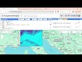
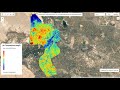
In this tutorial, you will explore how satellite remote sensing and field-based in-situ measurements can be combined to estimate and map Chlorophyll-a concentration in lakes, rivers, reservoirs, and coastal waters.
We will demonstrate a complete workflow using Sentinel-2 satellite imagery, spectral reflectance analysis, regression modeling, and validation with in-situ datasets using Google Earth Engine.
🔥 What You Will Learn
✔ Introduction to Chlorophyll-a and water quality monitoring
✔ Understanding in-situ water quality data
✔ Using Sentinel-2 imagery in Google Earth Engine
✔ Extracting spectral reflectance from satellite data
✔ Linking field measurements with satellite imagery
✔ Regression modeling for Chlorophyll-a estimation
✔ Water quality visualization and mapping
✔ Exporting results and analysis outputs
🌍 Why Chlorophyll-a Monitoring is Important?
Assess water quality and ecosystem health
Detect algal blooms and eutrophication
Monitor aquatic environmental changes
Support fisheries and water resource management
Improve environmental monitoring and research
Using Google Earth Engine and Remote Sensing, large-scale water quality monitoring becomes efficient and scalable.
🎯 Who Should Watch?
GIS & Remote Sensing students
Water quality researchers
Environmental scientists
Limnology and aquatic ecosystem researchers
Google Earth Engine users
📌 SEO Keywords
chlorophyll-a monitoring Google Earth Engine, water quality remote sensing tutorial, Sentinel-2 chlorophyll analysis, in-situ water quality data GIS, chlorophyll concentration mapping, aquatic remote sensing GEE.
🔥 SEO Tags
chlorophyll-a monitoring Google Earth Engine,water quality remote sensing tutorial,Sentinel-2 chlorophyll analysis,in-situ water quality data GIS,chlorophyll concentration mapping,aquatic remote sensing GEE,water quality modeling Sentinel-2,remote sensing limnology tutorial,Earth observation water analysis,geospatial water quality monitoring
🔥 High-Reach Hashtags
#WaterQuality
#ChlorophyllA
#GoogleEarthEngine
#RemoteSensing
#Sentinel2
#GIS
#Geospatial
#EarthObservation
#EnvironmentalMonitoring
#SpatialAnalysis
Видео Water Quality Monitoring: Chlorophyll-a Concentration Using In-Situ Data & Google Earth Engine канала Study Hacks-Institute of GIS & Remote Sensing
salinity mapping Sentinel-2 soil salinity Google Earth Engine Sentinel satellite salinity analysis saline soil detection remote sensing GEE salinity mapping tutorial soil degradation GIS remote sensing salinity monitoring Earth observation soil analysis geospatial salinity mapping Sentinel-2 agriculture analysis
Комментарии отсутствуют
Информация о видео
22 мая 2026 г. 2:47:19
00:19:59
Другие видео канала