- Популярные видео
- Авто
- Видео-блоги
- ДТП, аварии
- Для маленьких
- Еда, напитки
- Животные
- Закон и право
- Знаменитости
- Игры
- Искусство
- Комедии
- Красота, мода
- Кулинария, рецепты
- Люди
- Мото
- Музыка
- Мультфильмы
- Наука, технологии
- Новости
- Образование
- Политика
- Праздники
- Приколы
- Природа
- Происшествия
- Путешествия
- Развлечения
- Ржач
- Семья
- Сериалы
- Спорт
- Стиль жизни
- ТВ передачи
- Танцы
- Технологии
- Товары
- Ужасы
- Фильмы
- Шоу-бизнес
- Юмор
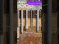
Hydrostatic Leveling
Despite the fashion-themed filename, this image illustrates a classic surveying technique using the principle of communicating vessels.
The Principle: Water in a connected tube will always reach the same height (elevation) at both ends due to gravity, regardless of the terrain between them. This creates a Uniform Hydrostatic Water Level (Datum).
The Process: * Surveyors use a flexible tube filled with liquid (often dyed distilled water for visibility).
By comparing the water level in the tube against a Precision Scale on a telescopic staff, they can calculate the exact height difference between two points (e.g., between a lower point at 100 ft and an upper point at 200 ft).
Why use it? It’s incredibly accurate for leveling over obstacles or around corners where a laser or optical level might have its line-of-sight blocked.
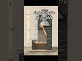
Видео Hydrostatic Leveling канала Max Engineer
The Principle: Water in a connected tube will always reach the same height (elevation) at both ends due to gravity, regardless of the terrain between them. This creates a Uniform Hydrostatic Water Level (Datum).
The Process: * Surveyors use a flexible tube filled with liquid (often dyed distilled water for visibility).
By comparing the water level in the tube against a Precision Scale on a telescopic staff, they can calculate the exact height difference between two points (e.g., between a lower point at 100 ft and an upper point at 200 ft).
Why use it? It’s incredibly accurate for leveling over obstacles or around corners where a laser or optical level might have its line-of-sight blocked.
Видео Hydrostatic Leveling канала Max Engineer
Комментарии отсутствуют
Информация о видео
3 мая 2026 г. 14:50:42
00:00:04
Другие видео канала