- Популярные видео
- Авто
- Видео-блоги
- ДТП, аварии
- Для маленьких
- Еда, напитки
- Животные
- Закон и право
- Знаменитости
- Игры
- Искусство
- Комедии
- Красота, мода
- Кулинария, рецепты
- Люди
- Мото
- Музыка
- Мультфильмы
- Наука, технологии
- Новости
- Образование
- Политика
- Праздники
- Приколы
- Природа
- Происшествия
- Путешествия
- Развлечения
- Ржач
- Семья
- Сериалы
- Спорт
- Стиль жизни
- ТВ передачи
- Танцы
- Технологии
- Товары
- Ужасы
- Фильмы
- Шоу-бизнес
- Юмор
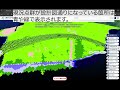
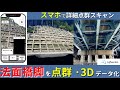
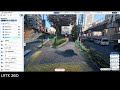
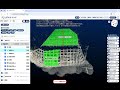
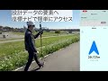
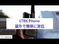
【LRTK Phone】RTK iPhone Photogrammetry: Georeferenced Point Clouds Up to 200 ft | LRTK
👉 Learn more about LRTK Phone: https://www.lefixea.com/phone
👉 Explore the LRTK platform: https://www.lefixea.com
This is RTK‑enabled smartphone photogrammetry (NOT iPhone LiDAR scanning).
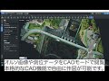
While iPhone LiDAR typically reaches only about ~6 m (≈20 ft), LRTK attaches to the back of an iPhone and automatically captures images with RTK‑accurate geotags—so you can turn photos into a georeferenced point cloud at distances up to ~60 m (≈200 ft), depending on conditions.
How it works:
• Mount LRTK on the back of your iPhone
• Walk and capture—photos are taken automatically
• Use RTK‑geotagged images to generate a georeferenced point cloud
⏱ Processing note:
Field capture can take about ~1 minute, and cloud processing typically takes around ~1 hour (depending on dataset size and conditions).
Perfect for:
• Surveying and construction documentation
• As‑built site capture and progress tracking
• Quick 3D context without a drone
📩 Request info / demo: https://www.lefixea.com/contact
#RTK #Photogrammetry #iPhone #PointCloud #Surveying #Construction #GNSS #AsBuilt
Видео 【LRTK Phone】RTK iPhone Photogrammetry: Georeferenced Point Clouds Up to 200 ft | LRTK канала LRTK Lefixea Inc.
👉 Explore the LRTK platform: https://www.lefixea.com
This is RTK‑enabled smartphone photogrammetry (NOT iPhone LiDAR scanning).
While iPhone LiDAR typically reaches only about ~6 m (≈20 ft), LRTK attaches to the back of an iPhone and automatically captures images with RTK‑accurate geotags—so you can turn photos into a georeferenced point cloud at distances up to ~60 m (≈200 ft), depending on conditions.
How it works:
• Mount LRTK on the back of your iPhone
• Walk and capture—photos are taken automatically
• Use RTK‑geotagged images to generate a georeferenced point cloud
⏱ Processing note:
Field capture can take about ~1 minute, and cloud processing typically takes around ~1 hour (depending on dataset size and conditions).
Perfect for:
• Surveying and construction documentation
• As‑built site capture and progress tracking
• Quick 3D context without a drone
📩 Request info / demo: https://www.lefixea.com/contact
#RTK #Photogrammetry #iPhone #PointCloud #Surveying #Construction #GNSS #AsBuilt
Видео 【LRTK Phone】RTK iPhone Photogrammetry: Georeferenced Point Clouds Up to 200 ft | LRTK канала LRTK Lefixea Inc.
Комментарии отсутствуют
Информация о видео
27 января 2026 г. 1:00:31
00:01:03
Другие видео канала