NOAA Titanic Expedition 2004: Breathtaking Wreck Footage
Breathtaking...
Nearly 20 years after first finding the sunken remains of the R.M.S. Titanic, marine explorer Robert Ballard returned in June 2004, helped by the NOAA Office of Ocean Exploration to study the ship's rapid deterioration.
The Titanic team worked aboard NOAA Ship Ronald H. Brown from May 30 through June 9, spending 11 days at the wreck site, mapping the ship and conducting scientific analysis of its deterioration.
The team used Institute for Exploration (IFE) remotely operated vehicles (ROVs) Hercules and Argus to conduct a sophisticated documentation of the state of Titanic was not possible in the 1980s.
This "look, don't touch" mission used high-definition video and stereoscopic still images to provide an updated assessment of the wreck site at a depth of 3,840 meters (12,600 feet).
As the nation's ocean agency, NOAA has a vested interest in the scientific and cultural aspects of the Titanic and in its appropriate treatment and preservation. NOAA's focus is to build a baseline of scientific information from which we can measure the shipwreck's processes and deterioration, and then apply the knowledge we gain to other deepwater shipwrecks and submerged cultural resources.
Video courtesy of the R.M.S. Titanic Expedition Team 2004, ROI, IFE, NOAA-OER.
Source: http://oceanexplorer.noaa.gov/explorations/04titanic/welcome.html
Google Map of wreck site location for the R.M.S. Titanic: http://go.usa.gov/XWk
Видео NOAA Titanic Expedition 2004: Breathtaking Wreck Footage канала oceanexplorergov
Показать
Комментарии отсутствуют
Информация о видео
Другие видео канала
 Titanic wreck HD
 Titanic Real Footage: Leaving Belfast for Disaster (1911-1912) | British Pathé
 Titanic - teoria potopenia od Jamesa Camerona
 NEW and IMPROVED! - Titanic - Death of a Titan - T.H.Cooney Art
 12 Most Amazing Abandoned Ships In The World
 Remembering Titanic - Part One
 New CGI of How Titanic Sank | Titanic 100
 डूबा हुआ टाइटैनिक समुन्द्र से आज तक क्यों नहीं निकाला गया? 12,500 फीट नीचे अब भी दफ़न हैं कईं राज़!
 The Titanic's Guggenheim State Rooms | Back to the Titanic
 Video and Technical Description of the Titanic's Wreck on the Ocean Floor
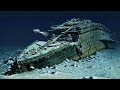 Why can't the Titanic be recovered from the bottom of the ocean
 Titanic Survivor Claims an Iceberg Didn't Destroy the Ship
 Here Comes the (Sun)fish: November 17, 2019
 TITANIC 90 Years Below part 6
 🖖Titanic sinking - 5 different simulations
 Titanic Underwater Footage (Wreck 1997)
 Titanic: The Facts Told By Real Survivors | British Pathé
 13 Amazing Items Recovered from Titanic
 Titanic Wreck | Stern | Virtual